Explore › Old maps › The places in the five books of Moses
Open the map in full size (3000 × 2481)Library of Congress, Geography and Map Division · public domain Old maps · 1826
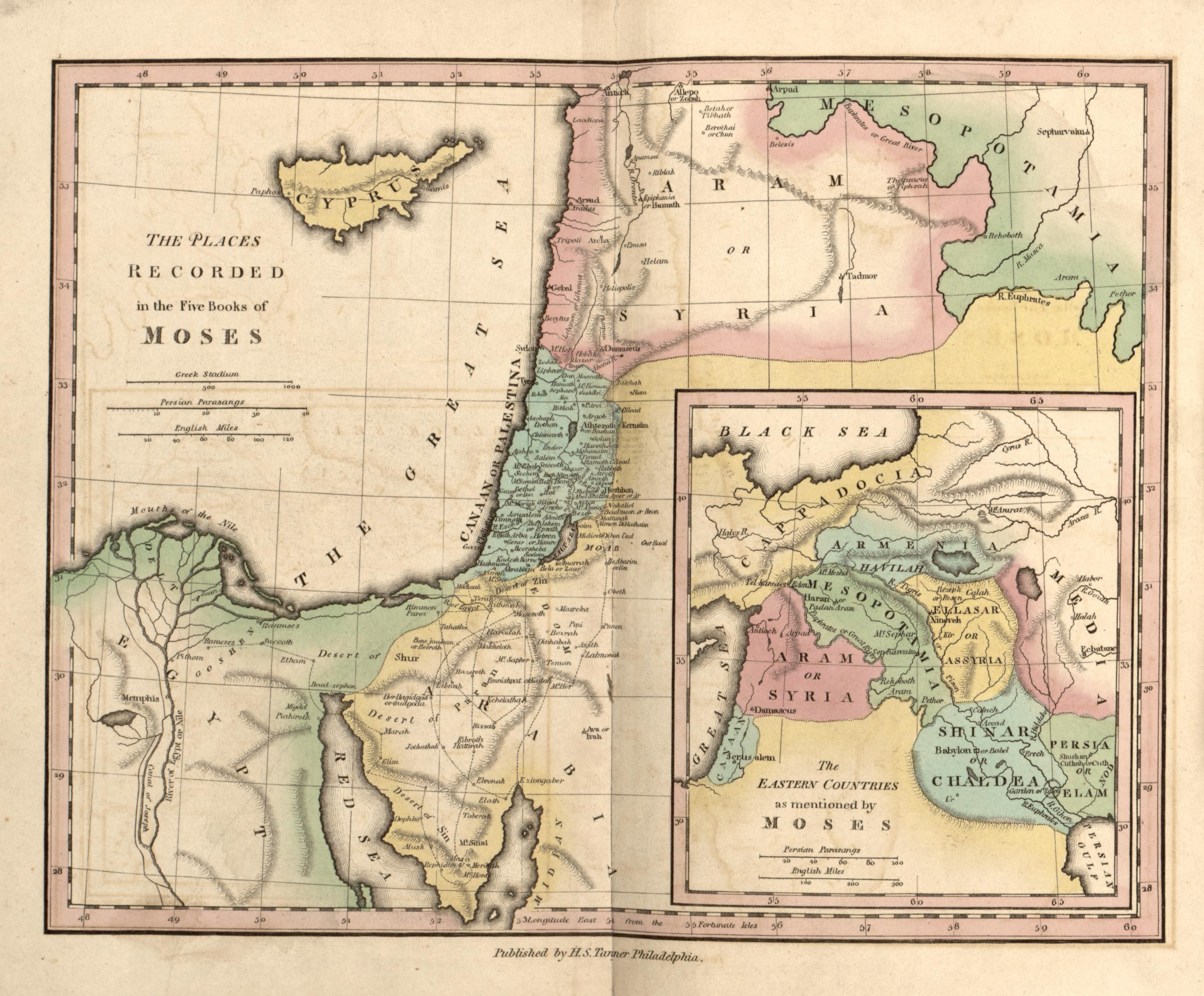
The places in the five books of Moses Mapmaker: Tanner, Henry Schenck · Year: 1826
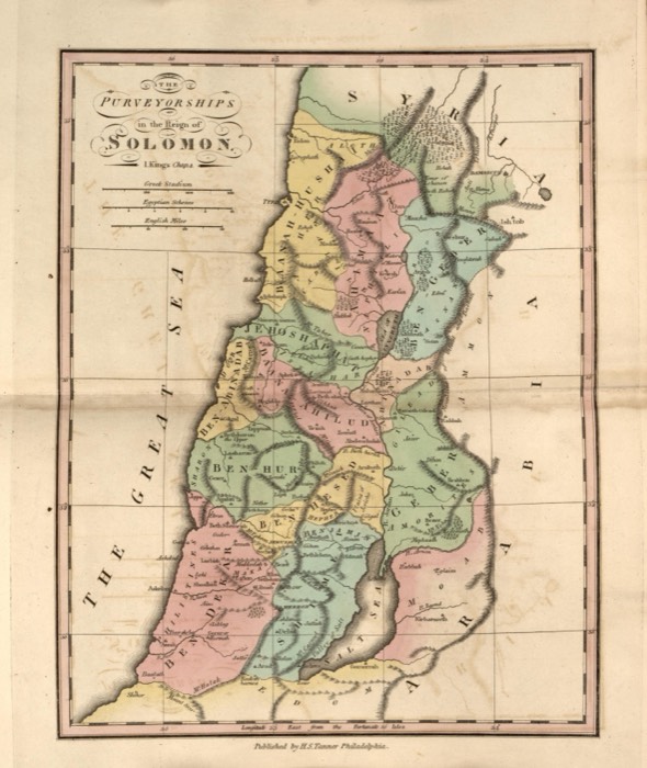
From «An Atlas of Ancient Geography», published by Henry S. Tanner in Philadelphia in 1826 «to elucidate the writings of the ancient authors, both sacred and profane». The main map runs from the Nile delta and Goshen across the desert of Sinai to Canaan and Syria; an inset shows «the eastern countries as mentioned by Moses», from Ararat in Armenia to Babylon and Elam.
The map at the Library of Congress
Old maps of the Holy Land, 1600–1881: Library of Congress, Geography and Map Division (public domain; item numbers found through Wikimedia Commons, images from the library’s own server); the texts are ours
Passages Gen 10:1–32 This is the account of Noah’s sons Shem, Ham, and Japheth, who also had sons after the flood. The sons of Japheth: Gomer, Magog, Madai, Javan, Tubal, Meshech, and Tiras. The sons of Gomer: Ashkenaz, Riphath, and Togarmah. And the sons of Javan: Elishah, Tarshish, the Kittites, and the Rodanites. From these, the maritime peoples separated into their territories, according to their languages, by clans within their nations. The sons of Ham: Cush, Mizraim, Put, and Canaan. The sons of Cush: Seba, Havilah, Sabtah, Raamah, and Sabteca. And the sons of Raamah: Sheba and Dedan. Cush was the father of Nimrod, who began to be a mighty one on the earth. He was a mighty hunter before the LORD; so it is said, “Like Nimrod, a mighty hunter before the LORD.” His kingdom began in Babylon, Erech, Accad, and Calneh, in the land of Shinar. From that land he went forth into Assyria, where he built Nineveh, Rehoboth-Ir, Calah, and Resen, which is between Nineveh and the great city of Calah. Mizraim was the father of the Ludites, the Anamites, the Lehabites, the Naphtuhites, the Pathrusites, the Casluhites (from whom the Philistines came), and the Caphtorites. And Canaan was the father of Sidon his firstborn, and of the Hittites, the Jebusites, the Amorites, the Girgashites, the Hivites, the Arkites, the Sinites, the Arvadites, the Zemarites, and the Hamathites. Later the Canaanite clans were scattered, and the borders of Canaan extended from Sidon toward Gerar as far as Gaza, and then toward Sodom, Gomorrah, Admah, and Zeboiim, as far as Lasha. These are the sons of Ham according to their clans, languages, lands, and nations. And sons were also born to Shem, the older brother of Japheth; Shem was the forefather of all the sons of Eber. The sons of Shem: Elam, Asshur, Arphaxad, Lud, and Aram. The sons of Aram: Uz, Hul, Gether, and Mash. Arphaxad was the father of Shelah, and Shelah was the father of Eber. Two sons were born to Eber: One was named Peleg, because in his days the earth was divided, and his brother was named Joktan. And Joktan was the father of Almodad, Sheleph, Hazarmaveth, Jerah, Hadoram, Uzal, Diklah, Obal, Abimael, Sheba, Ophir, Havilah, and Jobab. All these were sons of Joktan. Their territory extended from Mesha to Sephar, in the eastern hill country. These are the sons of Shem, according to their clans, languages, lands, and nations. All these are the clans of Noah’s sons, according to their generations and nations. From these the nations of the earth spread out after the flood. Num 33:1–49 These are the journeys of the Israelites when they came out of the land of Egypt by their divisions under the leadership of Moses and Aaron. At the LORD’s command, Moses recorded the stages of their journey. These are the stages listed by their starting points: On the fifteenth day of the first month, on the day after the Passover, the Israelites set out from Rameses. They marched out defiantly in full view of all the Egyptians, who were burying all their firstborn, whom the LORD had struck down among them; for the LORD had executed judgment against their gods. The Israelites set out from Rameses and camped at Succoth. They set out from Succoth and camped at Etham, on the edge of the wilderness. They set out from Etham and turned back to Pi-hahiroth, opposite Baal-zephon, and they camped near Migdol. They set out from Pi-hahiroth and crossed through the sea, into the wilderness, and they journeyed three days into the Wilderness of Etham and camped at Marah. They set out from Marah and came to Elim, where there were twelve springs and seventy palm trees, and they camped there. They set out from Elim and camped by the Red Sea. They set out from the Red Sea and camped in the Desert of Sin. They set out from the Desert of Sin and camped at Dophkah. They set out from Dophkah and camped at Alush. They set out from Alush and camped at Rephidim, where there was no water for the people to drink. They set out from Rephidim and camped in the Wilderness of Sinai. They set out from the Wilderness of Sinai and camped at Kibroth-hattaavah. They set out from Kibroth-hattaavah and camped at Hazeroth. They set out from Hazeroth and camped at Rithmah. They set out from Rithmah and camped at Rimmon-perez. They set out from Rimmon-perez and camped at Libnah. They set out from Libnah and camped at Rissah. They set out from Rissah and camped at Kehelathah. They set out from Kehelathah and camped at Mount Shepher. They set out from Mount Shepher and camped at Haradah. They set out from Haradah and camped at Makheloth. They set out from Makheloth and camped at Tahath. They set out from Tahath and camped at Terah. They set out from Terah and camped at Mithkah. They set out from Mithkah and camped at Hashmonah. They set out from Hashmonah and camped at Moseroth. They set out from Moseroth and camped at Bene-jaakan. They set out from Bene-jaakan and camped at Hor-haggidgad. They set out from Hor-haggidgad and camped at Jotbathah. They set out from Jotbathah and camped at Abronah. They set out from Abronah and camped at Ezion-geber. They set out from Ezion-geber and camped at Kadesh in the Wilderness of Zin. They set out from Kadesh and camped at Mount Hor, on the outskirts of the land of Edom. At the LORD’s command, Aaron the priest climbed Mount Hor and died there on the first day of the fifth month, in the fortieth year after the Israelites had come out of the land of Egypt. Aaron was 123 years old when he died on Mount Hor. Now the Canaanite king of Arad, who lived in the Negev in the land of Canaan, heard that the Israelites were coming. And the Israelites set out from Mount Hor and camped at Zalmonah. They set out from Zalmonah and camped at Punon. They set out from Punon and camped at Oboth. They set out from Oboth and camped at Iye-abarim on the border of Moab. They set out from Iyim and camped at Dibon-gad. They set out from Dibon-gad and camped at Almon-diblathaim. They set out from Almon-diblathaim and camped in the mountains of Abarim facing Nebo. They set out from the mountains of Abarim and camped on the plains of Moab by the Jordan across from Jericho. And there on the plains of Moab they camped by the Jordan, from Beth-jeshimoth to Abel-shittim.