Explore › Old maps › Old Testament map of Palestine
Open the map in full size (2239 × 3000)Library of Congress, Geography and Map Division · public domain Old maps · 1881
Old Testament map of Palestine Mapmaker: H.H. Hardesty (Firm) · Year: 1881
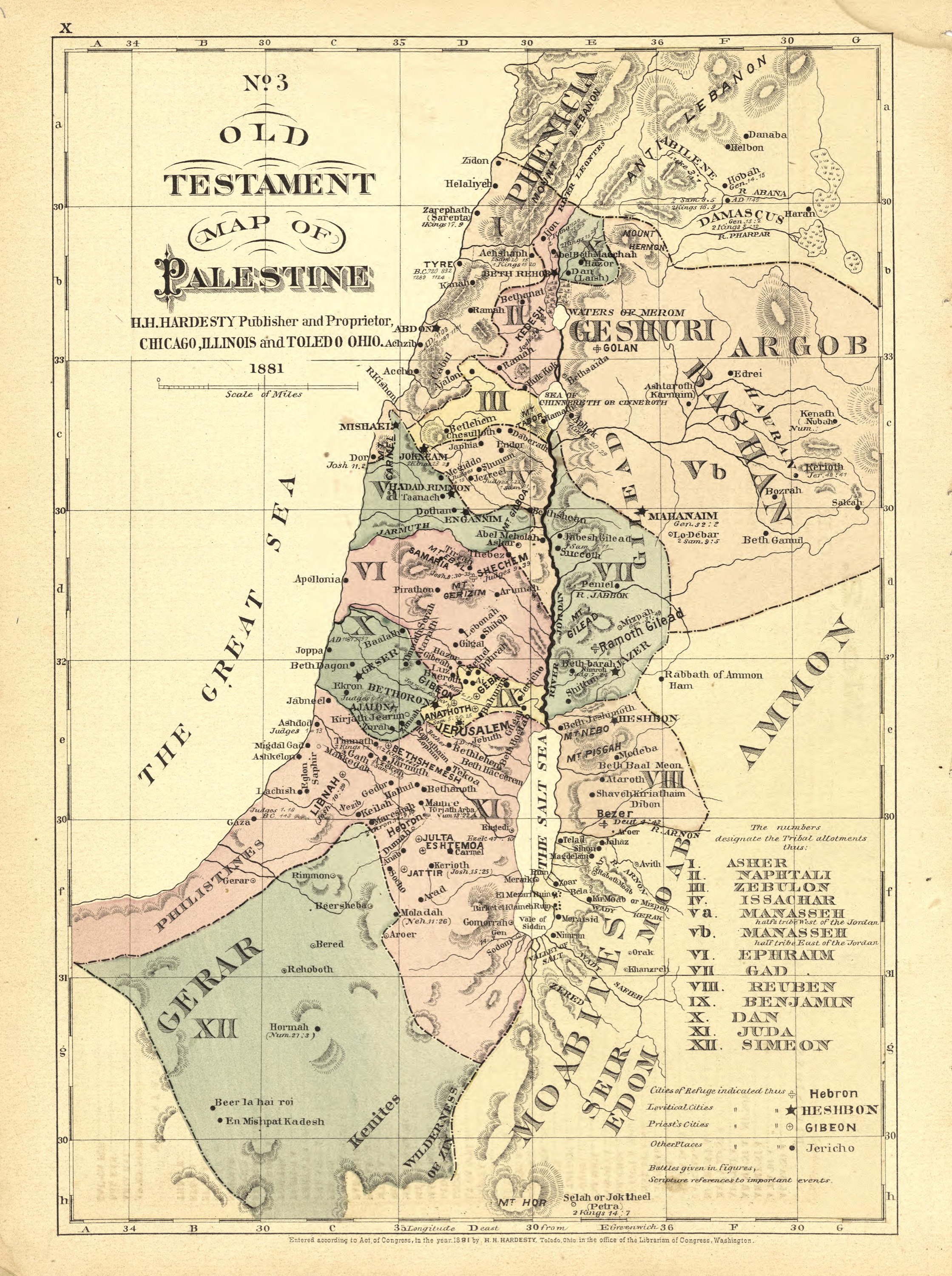
From the «Historical Hand-Atlas» published by H. H. Hardesty in Chicago and Toledo in 1881, which includes a numbered series of Bible maps. Map No. 3 numbers the twelve tribal allotments and marks the cities of refuge, the Levitical and priestly cities and the battles, with Scripture references beside many places.
The map at the Library of Congress
Old maps of the Holy Land, 1600–1881: Library of Congress, Geography and Map Division (public domain; item numbers found through Wikimedia Commons, images from the library’s own server); the texts are ours
Passages Josh 20:1–9 Then the LORD said to Joshua, “Tell the Israelites to designate the cities of refuge, as I instructed you through Moses, so that anyone who kills another unintentionally or accidentally may flee there. These will be your refuge from the avenger of blood. When someone flees to one of these cities, stands at the entrance of the city gate, and states his case before its elders, they are to bring him into the city and give him a place to live among them. Now if the avenger of blood pursues him, they must not surrender the manslayer into his hand, because that man killed his neighbor accidentally without prior malice. He is to stay in that city until he stands trial before the assembly and until the death of the high priest serving at that time. Then the manslayer may return to his own home in the city from which he fled.” So they set apart Kedesh in Galilee in the hill country of Naphtali, Shechem in the hill country of Ephraim, and Kiriath-arba (that is, Hebron) in the hill country of Judah. And beyond the Jordan, east of Jericho, they designated Bezer on the wilderness plateau from the tribe of Reuben, Ramoth in Gilead from the tribe of Gad, and Golan in Bashan from the tribe of Manasseh. These are the cities appointed for all the Israelites and foreigners among them, so that anyone who kills a person unintentionally may flee there and not die by the hand of the avenger of blood prior to standing trial before the assembly. Josh 21:1–42 Now the family heads of the Levites approached Eleazar the priest, Joshua son of Nun, and the heads of the other tribes of Israel at Shiloh in the land of Canaan and said to them, “The LORD commanded through Moses that we be given cities in which to live, together with pasturelands for our livestock.” So by the command of the LORD, the Israelites gave the Levites these cities and their pasturelands out of their own inheritance: The first lot came out for the Kohathite clans. The Levites who were descendants of Aaron the priest received thirteen cities by lot from the tribes of Judah, Simeon, and Benjamin. The remaining descendants of Kohath received ten cities by lot from the tribes of Ephraim, Dan, and the half-tribe of Manasseh. The descendants of Gershon received thirteen cities by lot from the tribes of Issachar, Asher, Naphtali, and the half-tribe of Manasseh in Bashan. And the descendants of Merari received twelve cities from the tribes of Reuben, Gad, and Zebulun. So the Israelites allotted to the Levites these cities, together with their pasturelands, as the LORD had commanded through Moses. From the tribes of Judah and Simeon, they designated these cities by name to the descendants of Aaron from the Kohathite clans of the Levites, because the first lot fell to them: They gave them Kiriath-arba (that is, Hebron), with its surrounding pasturelands, in the hill country of Judah. (Arba was the father of Anak.) But they had given the fields and villages around the city to Caleb son of Jephunneh as his possession. So to the descendants of Aaron the priest they gave these cities, together with their pasturelands: Hebron, a city of refuge for the manslayer, Libnah, Jattir, Eshtemoa, Holon, Debir, Ain, Juttah, and Beth-shemesh—nine cities from these two tribes, together with their pasturelands. And from the tribe of Benjamin they gave them Gibeon, Geba, Anathoth, and Almon—four cities, together with their pasturelands. In all, thirteen cities, together with their pasturelands, were given to the priests, the descendants of Aaron. The remaining Kohathite clans of the Levites were allotted these cities: From the tribe of Ephraim they were given Shechem in the hill country of Ephraim (a city of refuge for the manslayer), Gezer, Kibzaim, and Beth-horon—four cities, together with their pasturelands. From the tribe of Dan they were given Elteke, Gibbethon, Aijalon, and Gath-rimmon—four cities, together with their pasturelands. And from the half-tribe of Manasseh they were given Taanach and Gath-rimmon—two cities, together with their pasturelands. In all, ten cities, together with their pasturelands, were given to the rest of the Kohathite clans. This is what the Levite clans of the Gershonites were given: From the half-tribe of Manasseh they were given Golan in Bashan, a city of refuge for the manslayer, and Beeshterah—two cities, together with their pasturelands. From the tribe of Issachar they were given Kishion, Daberath, Jarmuth, and En-gannim—four cities, together with their pasturelands. From the tribe of Asher they were given Mishal, Abdon, Helkath, and Rehob—four cities, together with their pasturelands. And from the tribe of Naphtali they were given Kedesh in Galilee (a city of refuge for the manslayer), Hammoth-dor, and Kartan—three cities, together with their pasturelands. In all, thirteen cities, together with their pasturelands, were given to the Gershonite clans. This is what the Merarite clan (the rest of the Levites) were given: From the tribe of Zebulun they were given Jokneam, Kartah, Dimnah, and Nahalal—four cities, together with their pasturelands. From the tribe of Reuben they were given Bezer, Jahaz, Kedemoth, and Mephaath—four cities, together with their pasturelands. And from the tribe of Gad they were given Ramoth in Gilead, a city of refuge for the manslayer, Mahanaim, Heshbon, and Jazer—four cities in all, together with their pasturelands. In all, twelve cities were allotted to the clans of Merari, the remaining Levite clans. For the Levites, then, there were forty-eight cities in all, together with their pasturelands, within the territory of the Israelites. Each of these cities had its own surrounding pasturelands; this was true for all the cities.